🇬🇧 English

Graphic Solutions in 
Cultural Heritage & Civil Works

01

About us

AEROGRAPH STUDIO is a firm dedicated to graphic registration of Heritage and Civil Works in the Spanish territory and abroad, founded by specialized professionals since 1991 and with more than 250 clients like public institutions, universities, museums, architecture or engineering companies, and privates.
Our company carries out complete graphic services and solutions in maps, images, 3D models and CAD to front all kind of descriptive registration problems that are very common daily for archaeologists, engineers, architects and managers of cultural heritage. We develop a field and air work to make the design and edition of scientific productions for its publication or museography.

Aerograph Studio provides high quality graphics, always trying to meet the rising demands of our customers and proactively develop our work with new implementations. Our guarantee is the extensive experience and professional knowledge, from this perspective we focus our atention in becoming your personal graphic advisor.
02

Technology

Aerograph Studio uses in its services the best marks in precision topographic instrumentation as well as in computer, aerial and photographic systems of high performance and resolution, having of a wide range of means with periodic revisions in cleaning and calibration certified, that are employees by qualified professionals.
A good service needs the highest technical means to reach the highest quality standards, that's why we use renowned manufacturers such as LEICA, CANON, APPLE, DJI and DRONETOOLS.

In aerial photography systems we are constantly in innovation within the different recording techniques, personalizing and adapting the equipment provided by our suppliers to offer the customer the best graphic solution in each case. Aerograph has the appropriate civil liability insurance, LAPL Class flight license and authorization as operator by the Spanish Air Safety Agency (AESA).

Always demand a professional service of quality offered by experienced technicians and certified instruments.
03

Topographic Services

Aerograph Studio carries out all surveying and staking out operations at the service of the Technical Department in small and medium civil works, providing the engineer, architect or archaeologist with planimetric solutions in elevation, floor plan and profile of their projects, with total guarantee of precision and interpretation of terrain and architectural works. 
• Civil work topography: terrain surveying and staking out in a civil project with altimetric and georeferenced curvimetric dimensioning, surface measure and cubing of ground movement; leveling; triangulated MDT edition; presentation of floor plans, side elevation, profile and section in CAD vector format.
• Technical assistance in archaeological excavation: surveying structures and drawing vertices; georeferenced leveling; editing of vector planes with standardized discrimination of cultural and constructive phases; staking out and signaling of grids in archaeological sites.
• Photogrammetric support: survey of support vertices in plan and elevation for the 2D restitution of orthophotoplanes and 3D models.
04

3D Photogrammetry Services

Aerograph performs three-dimensional scans of terrain, archaeological sites, buildings and objects using SFM photogrammetric process (Structure From Motion) in medium or high image resolution (20-50 Mpx).
• Aerial photogrammetric survey up to 120 m legal height by octocopter dron (MTOW 10.7 kg), helium captive zeppelin (length 3.5 m) or telescopic mast (height 12 m).
• 3D modeling of objects in laboratory using Full-Frame DSLR camera and soft lighting equipment.
• Postproduction of drawings, plans and orthophotos from model.
• Editing, multilingual annotation and publication of models in a wide-spread 3D social network.
05

Aerial Photography Services

Aerograph performs video and aerial photography services using dron, captive helium zeppelin and telescopic mast equipped with high resolution camera (4K-8K).
• Zenithal and oblique aerial photography up to 120 m of legal height.
• Edited aerial video.
• Orthophotographic study of architectural side elevations using a 12 m mast.
• Orthorectification 2D of zenithal photograms with topographic assistance (orthophotoplanes)
• Stereophotography 3D in red/cyan anaglyph.
06

Cartography & CAD Services

Aerograph's professionals operate with high performance CAD systems for the editing of both vector graphics and high resolution images.

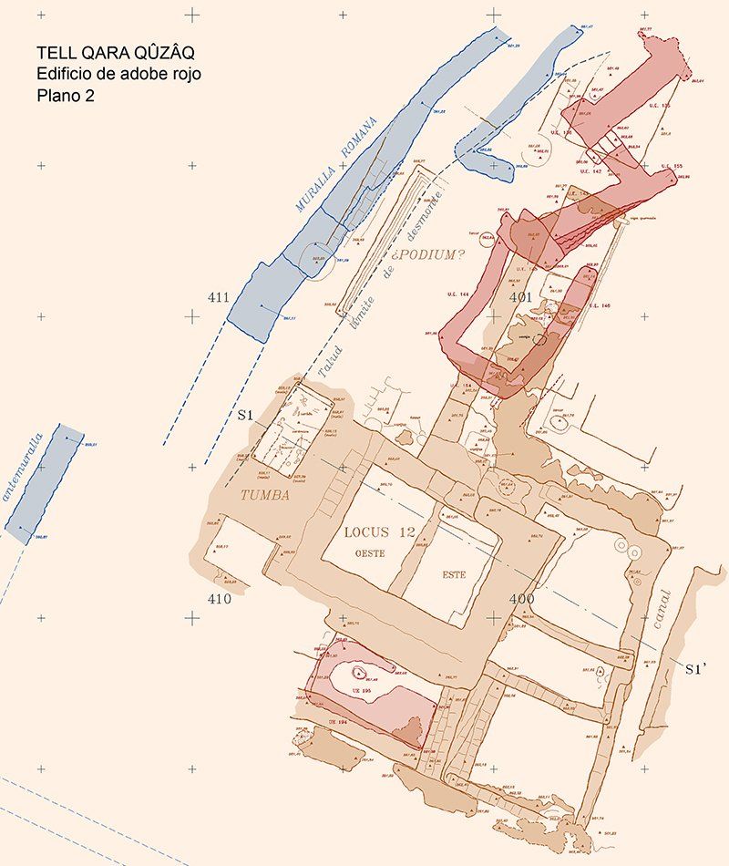
• 2D vector drawing: the 2D restitution of orthorectified aerial photographs shows the drawing of archaeological structures in CAD vector applications; the delineation of architectural elements is also executed for project plans.

• Illustration: illustrated color drawing in conventional standard systems of archaeological objects for scientific publication.

• Cartography & GIS: creation of thematic maps for publication; making and managing GIS.

• Poster: composition of posters in large format on documentary resources for graphic exposition.

• 3D virtual: virtual reconstructions in three dimensions of monuments and furniture with technical and scientific advice on their interpretation.

Some pics and videos of our works

Also you can visit a sample of our most recent 3D works on the Sketchfab design network:

Sketchfab

Most representative institutional clients

Contact now

Share by: